
Stretching for over 1500 kilometres, the Carpathian Mountains represent Europe’s third-longest mountain range by extension, after the Urals and the Scandinavian Mountains. They embrace numerous countries across central and eastern Europe, including the Czech Republic, Slovakia, Poland, Hungary, Serbia and Romania, and it is here that the main section is found: the Romanian Carpathians comprise exactly 50% of the entire mountain range.
The highest peak of the Romanian Carpathians is Moldoveanu, situated at an altitude of 2544 metres, in the heart of the Făgăraș mountains. Visiting this part of Romania is certainly rewarding from both a tourist and natural perspective: verdant valleys, snow-capped peaks, lakes and rivers, in an idyllic setting that remains relatively untouched by mass tourism, yet ideal for those seeking an active holiday in the great outdoors.
The Romanian Carpathians extend for approximately 750 kilometres, half the total length of the entire mountain chain; consequently, there are plenty of things to see. Here are their principal attractions.
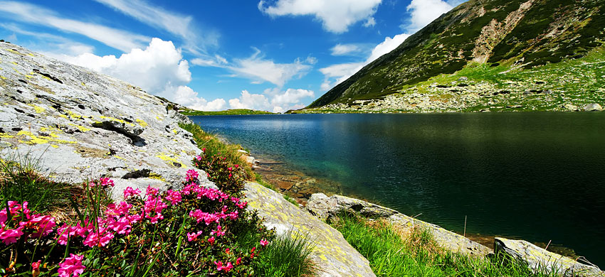
The Retezat National Park, Romania’s oldest, is located on the border between Transylvania and Oltenia, within the southern Carpathian chain, and spans between 800 and 2500 metres. The park covers 38,047 hectares of valleys and glacial lakes, 80 in total, of which 58 are permanent, and is home to 1190 species of higher plants, 12 fish species, 185 bird species and 55 mammal species.
The Bucura Lake is the largest, whilst the Zanoaga Lake is the deepest. The lakes are inhabited by certain fish species found only in Romania.
Amongst the most valuable plants are Lady’s Slipper orchids, certain types of gentian, hawksbeard, cornflower and edelweiss.
Amongst the birds that soar above Retezat Park are the magnificent Golden Eagle, the Peregrine Falcon, the White-tailed Eagle, the Short-toed Eagle, the Capercaillie, the Eurasian Eagle Owl, the Tengmalm’s Owl and the Black Stork.
Amongst the mammal fauna you will encounter wolves, brown bears, lynx, wildcats, as well as chamois, red deer, roe deer, otters and marmots.
Walking through the caves of Retezat Park, you can admire certain bat species, including the Greater Horseshoe Bat (rhinolophus ferrumequinum) and the Parti-coloured Bat (vespertilio murinus).
The Retezat National Park comprises two areas, including one of a scientific nature where access is permitted only with authorisation from the Nature Monuments Council.
The Cozia National Park is located in the north-east of the Vâlcea region, in the heart of the country. It is traversed by the Olt River, and with an area of 171 square kilometres, has been a protected area since 2000.
It is accessed via the national road DN7, passing through Râmnicu Vâlcea, Bujoreni, Malu Vârtop, Gura Văii, Călimănești and Păușa. From a tourist perspective, in addition to mountain trails, lakes and beautiful forests, there are also a series of highly interesting cultural sites to visit, including the church dedicated to the Birth of the Virgin Mary of Ostrov in Călimănești, dating from 1521, and the monasteries of Cozia, Stanniooara and Berislavvesti.
Located in the western part of Romania, not far from the border with Serbia, the Domogled-Valea Cernei National Park is situated between the counties of Caraș-Severin, Gorj and Mehedinți, within the watershed of the Cerna River.
The national park covers an area of over 60,000 hectares, where you can admire high mountains, valleys, waterfalls and a wide variety of flora and fauna, with some endemic species. Within it, Domogled-Valea Cernei National Park is divided into a series of protected areas, the most extensive of which is Coronini-Bedina, which alone occupies almost 4000 hectares.
The Rodna Mountains, or munţii Rodnei in Romanian, form part of the eastern inner Carpathians, in northern Romania, in the Maramureș region. They take their name from the village of Rodna Veche, and extend for 50 kilometres from east to west; the highest peak is Pietrosul Mountain, at a height of 2303 metres.
The Rodna Mountains are visited in summer for walking and in winter for skiing, using the resort of Borsa as a base; however, the Rodna Mountains are famous for their exceptionally long skiing season, such that in some years it has been possible to ski until July.
It is possible to walk around the Rodna Mountains following a series of trails; the route takes 3–5 days, depending on your level of fitness. A notable stop is at the Izvorul Tăuşoarelor, Romania’s deepest cave, which descends to 479 metres underground.
The entire Rodna Mountains area is part of the Rodna National Park and Biosphere Reserve, which covers 567 square kilometres.
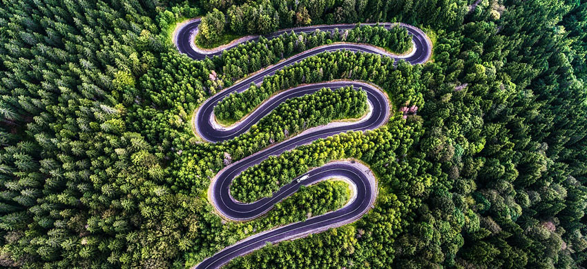
The DN7C road, or Transfăgărășan, is one of Romania’s most famous roads. At 90 kilometres long, it begins near the village of Bascov and extends to the junction with the DN1 road, passing alongside Romania’s two highest peaks, the Moldoveanu and Negoiu mountains.
The Transfăgărășan connects the regions of Transylvania and Wallachia, and was built in the 1970s for military purposes, during Nicolae Ceaușescu’s regime. It reaches an altitude of 2042 metres, making it Romania’s second-highest road after the Transalpina. Its legendary hairpin bends make it a must for mountain road enthusiasts and motorcyclists; some even dare to tackle its gradients by bicycle, though doing so requires considerable training.
Due to the area’s climatic conditions, the Transfăgărășan road is closed from mid-October to late June: keep this in mind if you plan to visit.
Finally, it is worth mentioning the ancient beech forests of the Carpathians and other regions of Europe, a UNESCO World Heritage site shared amongst 12 European countries, and one of the most extensive territorially on the entire list. In Romania, the protected forests are often part of national parks, and are:
 Hotel
Hotel  Budget accommodations
  Apartments
  Family Hotel
  Luxury Hotel